Consider Joining The WorldPressify Club

Unlimited Access to All Premium Plugins & Themes, Priority support, Automated Unlimited Lifetime Updates, Managed WordPress Hosting & More. From $14.99/Month

  Received 0 Ratings

Current Version: Latest Version

 

GET FREE TRIAL ON THE YEARLY SUBSCRIPTION

Advanced Google Maps Plugin for WordPress – WorldPress IFY

$4.99

  • 100% Original - All Premium Features Included.

    We Purchase and Download From Original Developers, to provide the most authentic & relevant version. Note: We're not directly affiliated or associated with PowerPack Elements for Elementor developers and we appreciate the authors' effort and original work. Names, expressions and trademarks are used to the minimum extent necessary to truthfully and accurately identify the item.

  • Safe & Secure

    The File Is Scanned Daily by Norton & McAfee to ensure safety, 100 % Free from Virus / Malware / Malicious Script etc. Run your own online Security check now (button under product image).

  • Unlimited Site & Domain Usage

    File can be used on as many sites as you want, in accordance to WordPress's GPL licensing policies. 

  • Updates Included (6 Months) - From WorldPressify

    We make sure that your site is always up to date, you will be notified the moment a new version is released on WorldPressify and the new download link automatically delivered to your email.

  • Why So Cheap?

    WordPress enforces the GPL/GNU license on ALL plugins & themes that 3rd party developers create for WordPress. The GPL license means that every script written for WordPress and their derivatives, must be free (Including all plugins and Themes). We are able to offer prices which are incredibly low for official items due to the fact we purchase all items directly from the authors and redistribute them to the public. The Price is a one-time price for full access, It's not a recurring payment. Original Author Support is not included if purchased from WorldPressify.


Advanced Google Maps Plugin for WordPress Discount – 93% OFF
This Google Maps Plugin for WordPress is the most advanced Google Maps plugin ever made. Using input from thousands of our valued clients, we built it.
Premium & Valuable Add-Ons for user interface enhancement!
We also sell our advanced google maps plugin premium extensions/add-ons that incorporate much needed & useful functionalities. These add-ons work seamlessly with our main plugin to generate very useful performance / content and display it on Google maps created by the main plugin in a beautiful way. Customers love it. Look at it!
Services for Customisation
We do a lot of customization with all of our plugins in our portfolio to suit our customers’ unique needs / specifications / business goals. By contacting us here, you can address your customization requirements or you can send an email to us at [email protected]. Our team is going to get back to you asap.
Features The Features
Easily filter locations using custom fields, taxonomies, and position data. Use the backend to create multiple filters.
Display posts, pages or styles of custom posts on Google maps. On a single Google map, you can display several types of messages.
Use meta boxes or your own custom fields to easily allocate locations to your article. You can also use the Advanced Custom Fields plugin to allocate your post to a venue.
Show information for posts in infowindows, e.g. title, text, extract, featured image, categories, tags, custom fields or custom taxonomies. To view such data, you just need to use placeholders.
Present posts listing below the map and display posts information in the listing. To incorporate your own template, you can easily customize HTML.
Advanced Google Maps Plugin for WordPress - WorldPress IFY
Show posts or positions in a grid or list format below the map. The visitor will migrate to a front-end format.
Attach some amount of position or marker information and quickly show it in an info window. For example, by fax, phone, email, website, etc.
Import from CSV unlimited position info. Any number of fields in a location can be imported. Assign categories using csv to your venue. Supported by all CSV delimiters.
Assign a locality to multiple categories and allow visitors to filter by categories.
Select to redirect to a location or click on the marker to show the info window message for all posts or manually added locations.
To filter posts or locations by zip, address, area, country, post tile or location title and categories, a full listing module for filtering, sorting, printing and advanced search box.
Ajax is focused on the listing module for the fastest usability and search experience.
Check within a certain distance for posts or positions nearby. Customize the Backend Radius Settings.
On the map, filter locations/markers by type. Capability filters at once for different categories.
In both ascending and descending order, sort listings by title, address or category.
Print filtered lists of places. The print choice can be managed through the backend.
Placeholders without any programming to edit position listing info.
Enable or disable search type, category filter, print option, backend sorting options.
Pagination is provided as a listing module. Using the backend environment, you can determine the number of posts or locations per page.
Ask the visitor’s start position and end location to show route directions. To automatically fill in the starting spot, press the marker. Get data on driving, biking, walking or transit routes.
For both miles and kilometers, tourists can get route directions.
Show the input to the start position as a textbox or pick a box filled with your location.
Display the input of the end position as a textbox or pick a box filled with your location.
Ability to show the default position of Start and End in the Directions tab.
Using Google places api, get nearby places within a certain range.
Show the circle of facilities discovered using Google API locations.
When you have too many locations, activate marker clusters. Only trigger it and the rest will be done by the plugin.
On both posts and places, you can apply marker clustering. The marker cluster is automatically modified upon filtration.
To boost user experience, select marker cluster icons and mouse-over icons. There are 10 marker cluster types available.
Pick the size of the marker cluster grid and max zoom level.
Create back-end routes and show them on the front-end. You may assign each route a color. The visitor may use the route filter type to show/hide routes on the front-end. On a Google map, you can display several routes.
To build a path, customize Stroke Color, Stroke Opacity, Stroke Weight, Travel Modes, Unit Systems, Start Position, End Place and way points.
Make it easy to drag the path and optimize waypoints to show the best possible route.
Assign the route with waypoints. Searchable location listings are added to easily assign waypoints for the route.
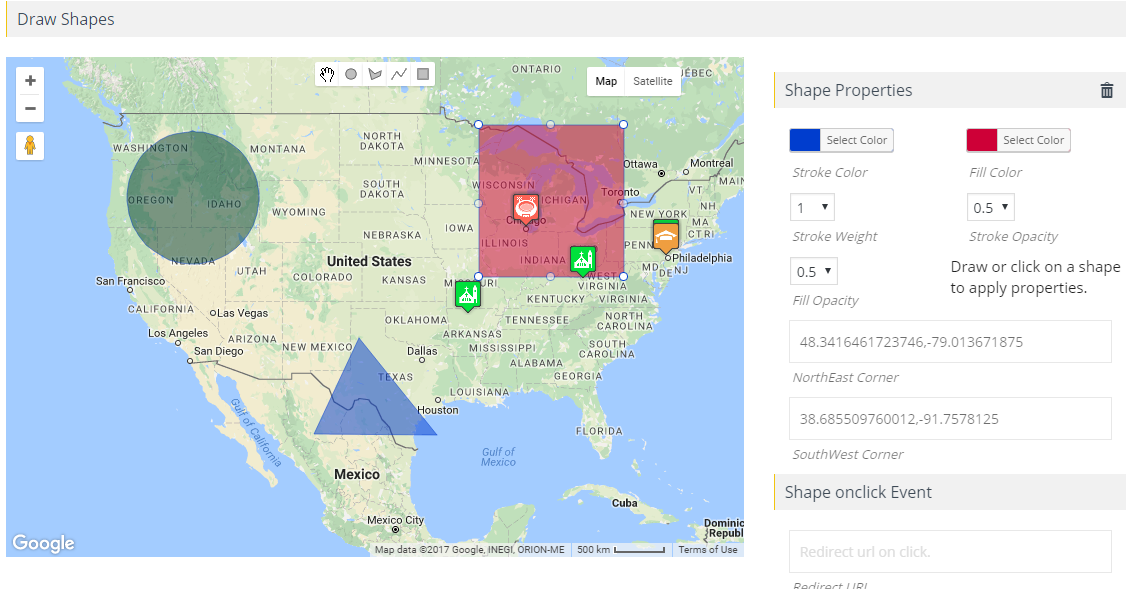
The administrator can draw and show any number of circles, rectangles, polygons or polylines on Google maps. Clickable shapes.
Click on a shape to show a details window.
Redirect to a position when a form is clicked.
Remove individual shapes or change the shape property by clicking on the button.
Draw on the map any number of shapes and save them all together.
Draw shapes using your own coordinates.
Apply snazzymaps.com’s amazing Google Maps types with a quick copy and paste.
You can make your own custom styles for your own Google Maps skin, as well as for paths, labels or geometry.
Fetch positions from external data sources, such as custom tables or APIs, and assign them to the map automatically using hooks.
Ability to automatically retrieve latitude, longitude, area, country, state and zip code when you type an address in the input field.
Manage parent-child classifications.
Assign groups to your own markers or pick from +500 readymade markers.
Ability to scan for relevant icons within the list of icons and easily add them to a group.
Use placeholders such as {marker title},{marker address},{marker message},{marker latitude},{marker longitude}, and configure the body of the message in the details window.
Show the marker-click or mouseover data window.
As page loads without clicking or mouseover, open infowindow.
Use programming to change infowindow contents by hook.
Close the Click Marker Details window. This function can be disabled on the backend.
Click or mouse over the dot to add Bounce Animation.
When they appear on Google maps, add Drop Animation to the marker.
Change the map’s zoom level by clicking on the marker for improved visibility.
Show on the map several KML/KMZ Layers.
Use the fusion table to show large numbers of data on a map. The best way for large sets of data to be handled.
Use Traffic Layers to show real time traffic conditions and overlays.
Use the Bicycling Layer to connect bicycle path data to your charts.
Physical maps based on terrain details are shown.
Ability to show several layers on the map together.
Set height, distance, zoom level, type of map, enable/disable scroll wheel, drag-and-drop property, and add 45° images.
Maps are fully sensitive and automatically configured according to the computer.
(Optional) Assign the latitude and longitude of the middle to the map. By default, the position of the core is determined automatically based on the positions assigned to the map.
Focus the map on the current position of the tourist.
To illustrate the center position, show a circle around the middle location. Set the ownership of the circle.
Using searchable listings, assign several locations to your map. Listings, if you have hundreds of places, are paginated.
Display/Hide Zoom Control, Full Screen Control, Map Style Control, Scale Control, Street View Control, Map Control Summary, and to assess the location of the map controls.
Hide page-load markers and show them only after filtration.
The street view of the place is revealed. Setup Street View POV Heading and POV Pitch to customize a location’s Street View performance.
Show overlays and customize the color of the border, width of overlay, height of overlay, font size, width of border and style of border.
Limit panning settings are the best way to restrict panning/dragging so that the map stays within those limits.
Fast view of GEOJSON data using URL.
Show maps in a combination of satellite and regular views.
Display Google Maps using the widget in the sidebars. The sidebar can show any number of charts.
Show Google Maps types, directions, roads, and local tabs together.
The position display counts with the group name. And order the groups by the number of assigned locations.
Maintain copies of positions, roads, charts and categories.
To control your location, categories, routes and maps, you can grant permissions to your users.
Ability to add markers on Google Maps using the new wpgmp marker source filter using External Database or Sources.
On a tab, add several Google maps. Each map will have its own characteristics.
A plugin compliant with cross-browsers. Checked absolutely on IE8, IE9, IE10 and all other major browsers
Multilingual Refers to .po files.
Multisite Activated and the ability to wide-network activate it.

Advanced Google Maps Plugin for WordPress Promo, Advanced Google Maps Plugin for WordPress GPL, Advanced Google Maps Plugin for WordPress pricing, Advanced Google Maps Plugin for WordPress offer, Advanced Google Maps Plugin for WordPress coupon, buy Advanced Google Maps Plugin for WordPress, Advanced Google Maps Plugin for WordPress download